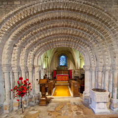
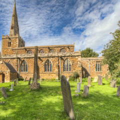
Tickencote St Peter
With a population of around 70 people this small village is a few miles north-west of Stamford next to the busy A1. The name derives from the Saxon Ticcen and Cote, meaning the place where goats and kids were herded when the country around was forest. The village lies on a slope from the Great North Road to the river Gwash below. At the time of the Domesday survey the manor was held by the Countess Judith and it passed eventually to...
Brooke Church St Peter
Three miles south-west of Oakham is the small village of Brooke which is at the head of the River Gwash. In 2001 the population was recorded as 211. Half a mile north of the village was the priory of St Mary of Brooke which was founded during the reign of King Stephen before 1153. By the 16th century it was mostly ruinous. Today there are some remains of the priory built into a later structure and I hope to add this as a separate...
Empingham St Peter
With a population of over 800 this village lies to the east of Rutland Water along the A606. On 12th March 1470 during the War of the Roses the Battle of Losecoat field took place near the village where the Yorkists under King Edward IV defeated the Lancastrians under Robert Welles, 8th Baron Willoughby de Eresby. It is reported that Lord Willoughby who was being held hostage by the King was beheaded before the battle in front of his...
Caldecott St John the Evangalist
Caldecott is the most southerly village in Rutland and is located about 4 miles south of Uppingham and today has a population of approx 260 people (2001 census). The village was mentioned in the in the Domesday as attached to Liddington (Lyddington) and held by the Bishop of Lincoln. In 1246 the Hospitallers were granted a free warren in their demesne lands in Caldecott. There was also a Snelson village that lay to the north of the...
Tilton on the Hill St Peter
With a population of around 450 Tilton is approximately 10 miles east of Leicester in some fine Leicestershire countryside. The village is sited on some of the highest ground in Leicestershire at 719 feet above sea level. In the Domesday Book survey of 1086 there was a priest so it is highly likely a previous structure church stood on the site. There is also evidence that the village is sited on a Bronze Age crossroads. The earliest...
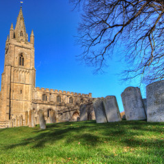
Great Casterton St Peter & St Paul
This village with a population of 434 (2001 census) is only two and a half miles from Stamford and hence very near to the county border of Lincolnshire. The remains of a Roman fort and town have been found northwest of the church with earthworks still remaining. The manor passed to the House of Lancaster and the remaining manors were passed through many families and you can read more on this by following the link to the excellent...
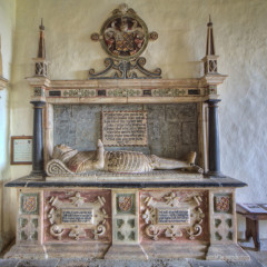
Stoke Dry St Andrew
Stoke Dry is small village in Rutland of around 14 dwellings just two miles south of Uppingham. It overlooks Eyebrook reservoir and has views into Leicestershire & Northamptonshire across the Welland valley. It is sited on a slope and in the Domesday Book was part of the manor of Lyddington and hence the Bishop of Lincoln. There is of course far more information on the manor and early years at the British History site and I have...
Lyndon St Martin
Just a few miles south of Rutland Water is the small village of Lyndon which in 2001 had a recorded of around eighty people. It is rather a ‘blink’ and you’ll miss it village with most of the properties away from the main road but it is a pretty little place with a nicely situated church. The parish is not mentioned in the Domesday Book but was probably one of the outlying ‘berewicks’ of Hambleton which...
About LeicesterPhoto
Need professional imagery solutions?
From aerial work to 360° solutions including Google Streetview we offer professional service and results.

Aerial Photography & Video
Fully insured and BNUSc qualified drone pilot for aerial photography and video. From weddings to surveys of historical buildings - get the best possible perspective. Click the drone to find out more..

Latest Comments